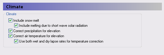
Climate
1. Overview
Precipitation is always included in the data tree.
Include snow melt
If snowmelt is included, then Evapotranspiration must also be specified in the Simulation Specification dialog. When snow melt is included, then a new Snow Melt section is added to the data tree where the various snow melt parameters can be specified.
Include melting due to short wave radiation
When the Snow melt option is selected, then the check box for radiation melting will become editable.
This option will add a new section to the climate data for incoming short-wave radiation. Also added will be an item in the Snow Melt section for the Melting Coefficient for Solar Radiation, which defines the rate at which the snow melts per unit of incoming radiation.
Elevation corrections
Correct precipitation for elevation
In mountainous areas, precipitation can vary significantly with elevation - especially on the windward side of the mountains. However, there are rarely enough rain gauging stations to measure this spatial variability of rainfall. Choosing to correct the precipitation for elevation allows you to define a spatially variable correction factor, if you are using sub area-based rainfall data. See Precipitation Lapse Rate for the correction equations.
Correct temperature for elevation
In mountainous areas, temperature varies significantly with elevation. Choosing to correct the temperature for elevation allows you to define a spatially variable correction factor, if you are using sub area-based temperature data. See Temperature Lapse Rate for the correction equations.
Use both wet and dry lapse rates for temperature correction
The moisture content of the air is a significant factor for the elevation correction of temperature. If this option is chosen, then you can specify a different correction factor for the time steps when it is raining.
Related Items
- Time Series Data
- Air Temperature
- Precipitation Rate
- Reference Evapotranspiration
- Short Wave Solar Radiation
- Snow Melt
- Snow Melt - Technical Reference
- Working with Freezing and Melting - User Guide
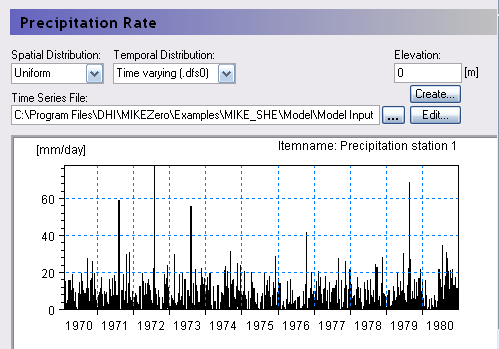
2. Precipitation Rate
| Precipitation Rate | |
|---|---|
| dialogue Type: | Time-varying Real Data |
| EUM Data Units | Grid Code |
| Time Series EUM Data Units | Precipitation Rate [e.g. mm/hr], or Rainfall [e.g. mm] |
The precipitation rate is the measured rainfall, or snowfall in rainfall equivalent units.
You can specify the precipitation rate as a rate, for example in [mm/hr], or as an amount, for example in [mm]. If you use an amount, MIKE SHE will automatically convert it to a rate during the simulation.
If you use a rate, then the EUM Data Units must be Precipitation and the time series must be Mean Step Accumulated.
If you use an amount, then the EUM Data Units must be Rainfall and the time series must be Step Accumulated.
The Precipitation Rate item comprises both a distribution and a value. The distribution can be either uniform, sub area-based or fully distributed. If the data is sub area-based then for each station a sub-item will appear where you can enter the time series of values for the station.
If Include snow melt is included and the Air Temperature is below the Threshold Melting Temperature, The threshold melting temperature is the temperature at which the snow starts to melt - usually 0 C. If the air temperature is above this threshold, then the snow will melt at the rate specified in the Degree-day Melting or Freezing Coefficient item. If the air below, then the precipitation will accumulate as snow.
Elevation
This is the station elevation. It is used as the reference elevation if the cell-by-cell precipitation is to be corrected for elevation differences (See Elevation corrections). The actual precipitation in each cell will then be calculated based on the elevation of the cell relative to the station elevation and the Precipitation Lapse Rate. Elevation correction is not available for fully distributed precipitation data.
Related Items
- Precipitation Lapse Rate
- Creating Time Series in MIKE SHE
- Working with Spatial Time Series
- Time Series Types
3. Precipitation Lapse Rate
| Precipitation Lapse Rate | |
|---|---|
| Conditions | if Correct precipitation for elevation checkbox is on in the Climate dialog |
| dialogue Type | Stationary Real Data |
| EUM Data Units | Correction of precipitation (e.g. % per 100m) |
Precipitation is typically measured at only a few locations within a watershed, but in mountainous areas the actual precipitation in an area can be strongly influenced by elevation - especially on the windward side of the mountains. The Precipitation Lapse Rate is used to estimate local precipitation based on the relative elevation difference to the weather station. The precipitation in the cell, Pcell, is calculated as

Equation 11.02
where:
- \(P_{station}\) is the measured precipitation at the weather station
- \(H_{station}\) is the elevation of the station
- \(H_{cell}\) is the elevation of the cell
- \(\beta_{cell}\) is the Precipitation Lapse Rate for the cell in units of, for example, [% change per 100m of elevation difference].
Related Items
4. Net Rainfall Fraction
| Net Rainfall Fraction | |
|---|---|
| Conditions | If Evapotranspiration is NOT selected |
| dialogue Type | Stationary Real Data |
| EUM Data Units | Fraction |
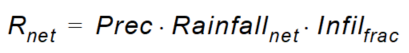
The Net Rainfall Fraction is the fraction of rainfall that is available for infiltration and overland flow. It is used to account for leaf interception and evapotranspiration when ET is not explicitly simulated.
The net recharge to the groundwater table, Rnet, is
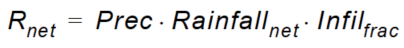
Equation 11.03
where:
- \(Prec\) is the actual precipitation
- \(Rainfall_{net}\) is the Net Rainfall Fraction
- \(Infil_{frac}\) is the Infiltration fraction.
Related Items
5. Infiltration Fraction
| Infiltration Fraction | |
|---|---|
| Conditions | If Overland flow is simulated but unsaturated flow is NOT simulated. |
| dialogue Type | Stationary Real Data |
| EUM Data Units | Fraction |
The Infiltration Fraction is the fraction of ponded water that infiltrates. It is used when the unsaturated zone is not explicitly simulated.
Normally the unsaturated zone simulation calculates the amount of infiltration from overland flow, since the amount of infiltration depends on the water content of the upper most soil horizon. If the soil is saturated, then the infiltration will be low. If the soil is very dry, then the infiltration could be very high.
However, the Net Infiltration Fraction is a stationary variable. The only way to simulate the dynamic changes in the amount of infiltration is to simulate the unsaturated zone.
!!Note
When a river is used in MIKE SHE, overland flow must always be included. If you want to simulate strictly saturated flow coupled to a river model, then you will need to use the Infiltration Fraction instead of the unsaturated flow.
The net recharge to the groundwater table, Rnet, is
Equation 11.04
where:
- \(Prec\) is the actual precipitation
- \(Rainfall_{net}\) is the Net Rainfall Fraction
- \(Infil_{frac}\) is the Infiltration fraction.
Related Items
6. Reference Evapotranspiration
| Reference Evapotranspiration | |
|---|---|
| dialogue Type | Time-varying Real Data |
| EUM Data Units | Grid Code |
| Time Series EUM Data Units | Evapotranspiration Rate |
The reference ET value is independent of everything but climate and can be calculated from weather data. The FAO Penman-Monteith method is recommended for determining the reference ET value.
The Reference ET is multiplied by the Crop Coefficient to get the Crop Reference ET. The Crop Coefficient is found in the Vegetation development table in the Vegetation database. If the vegetation database is not used, then the Reference ET is the maximum ET rate.
The Reference Evapotranspiration item comprises both a distribution and a value. The distribution can be either uniform, sub area-based or fully distributed. If the data is sub area-based then for each station a sub-item will appear where you can enter the time series of values for the station.
Related Items
- Creating Time Series in MIKE SHE
- Working with Spatial Time Series
- Time Series Types
- Vegetation Properties Editor
- Evapotranspiration - Technical Reference
- Working with Evapotranspiration - User Guide
7. Short Wave Solar Radiation
| Short Wave Solar Radiation | |
|---|---|
| Conditions | if melting due to short wave radiation is checked on in Climate dialog |
| dialogue Type | Time-varying Real Data |
| EUM Data Units | Grid Code |
| Time Series EUM Data Units | Radiation intensity; Instantaneous |
This is the intensity of the incoming shortwave solar radiation. This value is typically measured at a weather station. It is used to calculate the amount of additional snowmelt due to adsorption of the radiation.
Solar radiation varies with latitude and time of day, as well as the degree of cloud cover. It also depends on the pitch of the slope and its angle towards the south. Thus, the peak radiation will be experienced at midday on moderately sloped, south facing slopes.
Daily average values will typically underestimate the amount of snow melt. So model time steps and input data that account for the diurnal fluctuations in radiation will give better results.
Spatially constant values should be reasonable for large areas, but you may need to correct radiation data in mountainous catchments when the sub area-based data has been measured in the valley.
Related Items
- Creating Time Series in MIKE SHE
- Working with Spatial Time Series
- Time Series Types
- Climate
- Snow Melt - Technical Reference
- Working with Freezing and Melting - User Guide
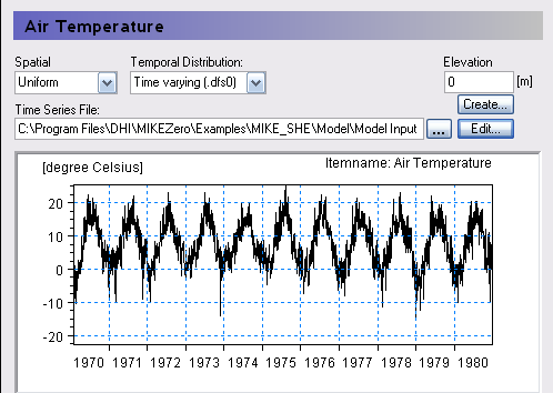
8. Air Temperature
| Air Temperature | |
|---|---|
| Conditions | if Snow melt selected, or if Temperature Dependent Decay is selected |
| dialogue Type | Time-varying Real Data |
| EUM Data Units | Grid Code |
| Time Series EUM Data Units | Temperature; Instantaneous |
Elevation
This is the station elevation. It is used as the reference elevation if the cell-by-cell temperatures are to be corrected for elevation differences (See Elevation corrections). The elevation correction is specified by the Temperature Lapse Rate, or optionally by the Wet Lapse Rate if it is raining. Elevation correction is not available for fully distributed temperature data.
Snowmelt
This is the temperature in Celsius that is used to calculate snow melt and accumulation:
- If the Air temperature is below the Threshold Melting Temperature value, then the precipitation accumulates as snow; above it is treated as rain.
- If the Air temperature is above the Threshold Melting Temperature value, then dry snow is converted to wet snow using the Degree-day Melting or Freezing Coefficient.
- If the Air temperature is below the Threshold Melting Temperature value, then wet snow is converted to dry snow using the Degree-day Melting or Freezing Coefficient.
Temperature Dependent Decay
This is the air temperature used for calculating the soil temperature for temperature dependent decay in the water quality module.
Related Items
- Creating Time Series in MIKE SHE
- Working with Spatial Time Series
- Time Series Types
- Snow Melt
- Threshold Melting Temperature
- Degree-day Melting or Freezing Coefficient
- Decay
- Snow Melt - Technical Reference
- Working with Freezing and Melting - User Guide
9. Temperature Lapse Rate
| Temperature Lapse Rate | |
|---|---|
| Conditions | if Correct temperature for elevation checkbox is on in the Climate dialog |
| dialogue Type | Stationary Real Data |
| EUM Data Units | Temperature Lapse Rate (e.g. C per 100m) |
Temperature is typically measured at only a few locations within a watershed, but in mountainous areas the actual temperature at a location is strongly influenced by elevation. The Temperature Lapse Rate is used to estimate local temperature based on the relative elevation difference to the weather station. The temperature in the cell, Tcell, is calculated as
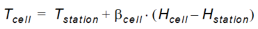
Equation 11.05
where:
- \(T_{station}\) is the measured temperature at the weather station
- \(H_{station}\) is the elevation of the station
- \(H_{cell}\) is the elevation of the cell
- \(\beta_{cell}\) is the Temperature Lapse Rate for the cell in units of, for example, [degrees C per 100m of elevation difference]. \(*\beta_{cell}\)* is a negative value since temperature decreases with increasing elevation.
However, the moisture content of the air is a significant factor for the elevation correction of temperature. Thus, you have the option in the Climate dialog to specify a different correction factor for the time steps when it is raining.
Related Items
10. Wet Lapse Rate
| Wet Lapse Rate | |
|---|---|
| Conditions | if Correct temperature for elevation checkbox is on in the Climate dialog |
| dialogue Type | Stationary Real Data |
| EUM Data Units | Temperature Lapse Rate (e.g. C per 100m) |
The moisture content of the air is a significant factor for the elevation correction of temperature. Thus, you have the option in the Climate dialog to specify a different correction factor for the time steps when it is raining.
If there is precipitation during the time step, then the Wet Lapse Rate will be used in Equation (11.5).
Related Items
- [Climate()
- Air Temperature
- Temperature Lapse Rate
11. Snow Melt
The Snow Melt data sub-tree includes all of the specific parameters related to the snow melt module.
Snow melts by converting from dry snow to wet snow. Wet snow is converted to overland flow when the Maximum Wet Snow Fraction in Snow Storage is exceeded.
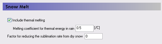
Include thermal melting
Thermal melting of snow in response to the heat content of rain can be an important factor during spring thaw events, where rain on saturated snow can trigger a significant flood. The rain is assumed to be at the same temperature as the air.
Melting coefficient for thermal energy in rain
The melting coefficient accounts for the energy content or the rain.
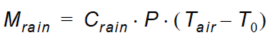
Equation 11.06
where:
- \(M_{rain}\) is the melting rate
- \(C_{rain}\) is the melting coefficient due to the energy content of the rain
- \(P\) is the precipitation rate
- \(T_{air}\) is the current air temperature
- \(T_0\) is the Threshold Melting Temperature.
Factor for reducing the sublimation rate from dry snow -
The ET module will remove water from snow storage before any other ET is removed.
- ET is removed first from wet snow as evaporation because the energy requirements for evaporation are lower than sublimation. The ET is removed from wet snow at the full rate, assuming that wet snow can be treated the same as ponded water.
- If there is no wet snow (either because it is too cold, or all the wet snow has been evaporated) then ET will be removed from dry snow as sublimation.
However, sublimation has a higher energy requirement than evaporation, so MIKE SHE includes a user defined factor for controlling sublimation. The sublimation factor is a multiplier that reduces the actual ET rate from the snow. If the sublimation factor = 0, then the ET rate is 0. If the sublimation factor = 1.0, then the ET rate is the specified Reference ET rate. Thus,
\(Maximum ET = (Reference ET) * (Crop Coefficient) * (Sublimation Factor)\)
Related Items
- Climate
- Air Temperature
- Snow Melt - Technical Reference
- Working with Freezing and Melting - User Guide
12. Threshold Melting Temperature
| Threshold Melting Temperature | |
|---|---|
| Conditions | if Snow melt included in n the Climate dialog |
| dialogue Type | Stationary Real Data |
| EUM Data Units | Temperature |
The threshold melting temperature is the temperature at which the snow starts to melt - usually 0 C. If the air temperature is above this threshold, then the snow will melt at the rate specified in the Degree-day Melting or Freezing Coefficient item. If the air temperature falls below
Related Items
- Degree-day Melting or Freezing Coefficient
- Air Temperature
- Snow Melt - Technical Reference
- Working with Freezing and Melting - User Guide
13. Degree-day Melting or Freezing Coefficient
| Degree-day Melting or Freezing Coefficient | |
|---|---|
| Conditions | if Snow melt included in the Climate dialog |
| dialogue Type | Time-varying Real Data |
| EUM Data Units | Grid code |
| Time Series EUM Data | Melting coefficient [e.g. mm snow/day/degree C] Units |
The degree day factor is the amount of snow that melts per day for every degree the Air Temperature is above the Threshold Melting Temperature.
The degree day factor is a time varying coefficient because the rate of melting varies as the snowpack changes over the winter. The melting coefficient is often used as a calibration parameter to calibrate the volume of snow melt to the observed runoff.
Related Items
- Threshold Melting Temperature
- Air Temperature
- Snow Melt - Technical Reference
- Working with Freezing and Melting - User Guide
14. Melting Coefficient for Solar Radiation
| Melting Coefficient for Solar Radiation | |
|---|---|
| Conditions | if radiation melting is included in the Climate dialog |
| dialogue Type | Stationary Real Data |
| EUM Data Units | Radiation melting coefficient [e.g. mm/(KJ/m2)] |
The melting coefficient for solar radiation represents that depth of dry snow converted to wet snow per unit of incoming short-wave radiation.
In principle, radiation melting coefficient is a time varying parameter that varies as the snow darkens with age. However, the degree-day melting coefficient is the primary calibration parameter for calibrating runoff.
Related Items
- Short Wave Solar Radiation
- Snow Melt - Technical Reference
- Working with Freezing and Melting - User Guide
15. Minimum Snow Storage for Full Area Coverage
| Minimum Snow Storage for Full Area Coverage | |
|---|---|
| Conditions | if Snow melt included in the Climate dialog |
| dialogue Type | Stationary Real Data |
| EUM Data Units | Storage depth [e.g. mm] |
Snow tends not to be uniformly distributed. It tends to be deeper in sheltered areas, such as along fence lines and in wooded areas.
The Minimum storage depth allows you to assign a minimum snow thickness that covers the entire cell with snow. Snow depths below this value will linearly reduce the snow cover area. The Minimum storage depth reduces the melting rate by an area fraction, thereby preventing small amounts of snow from instantly melting.
The default value of zero implies that no area reduction occurs and that all snow is deposited evenly across the cell.
Related Items
16. Maximum Wet Snow Fraction in Snow Storage
| Maximum Wet Snow Fraction in Snow Storage | |
|---|---|
| Conditions | if Snow melt included in the Climate dialog |
| dialogue Type | Stationary Real Data |
| EUM Data Units | Fraction [-] |
Melting snow does not instantly lead to runoff. When snow melts, the liquid water content of the snow first increases until a critical water content is reached. When this water content is reached additional melted snow will form runoff. If the air temperature drops below freezing the liquid water stored in the snow will re-freeze. This repeated thawing and freezing leads to snow compaction and changes in the snow structure over the winter. This in turn justifies the time dependency of the Degree-day Melting or Freezing Coefficient.
The snow storage is divided into Dry snow storage and Wet snow storage, where the wet snow is actually absorbed liquid water in the snow structure. The wet snow fraction is the amount of wet snow divided by the total amount of snow storage. When the Maximum wet snow fraction is exceeded, any excess melted snow will be converted to ponded water. The ponded water is then available for UZ infiltration, evapotranspiration, or overland runoff.
Related Items
17. Initial Total Snow Storage
| Initial Total Snow Storage | |
|---|---|
| Conditions | if Snow melt included in the Climate dialog |
| dialogue Type | Stationary Real Data |
| EUM Data Units | Storage depth [e.g. mm] |
This is the initial total storage depth of snow in the cell. This value is used to also determine the initial snow coverage on the cell. Thus, if this value is less than the Minimum Snow Storage for Full Area Coverage, then the area coverage fraction will be less than one.
Related Items
- Minimum Snow Storage for Full Area Coverage
- Snow Melt - Technical Reference
- Working with Freezing and Melting - User Guide
18. Initial Wet Snow Fraction
| Initial Wet Snow Fraction | |
|---|---|
| Conditions | if Snow melt included in the Climate dialog |
| dialogue Type | Stationary Real Data |
| EUM Data Units | Fraction [-] |
The Initial Wet Snow Fraction determines the initial liquid water content of the snow storage. If this value is greater than the Maximum Wet Snow Fraction in Snow Storage, then runoff will be generated in the first time step. If this value is zero, then the initial snow is dry.
Related Items
- Maximum Wet Snow Fraction in Snow Storage
- Snow Melt - Technical Reference
- Working with Freezing and Melting - User Guide
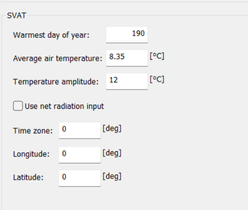
19. SVAT
SVAT requires a set of global data:
- Warmest day of the year (0-365)
- Average air temperature (in degrees Celcius)
- Temperatur-e amplitude (in degrees Celcius)
- Time zone
- longitude
- Latitude